
Why is no 368 next to no 294?
05/07/14 22:36
Going through a neighbour’s deeds I found a list of tenants paying ground rent to the owners of Springhill Farm, together with date of tenancy and rent paid. Double checking which house was where showed that the numbers on the north side of Newchurch Road descend in order (apart from 388A but hey) from 420 to 368, all where you would expect them to be.
There is then a 20 yard gap with the entrance to Marl Pits sports ground.
The houses then resume with no 294 and descend in sequence from there down to Rawtenstall about 1/2 mile away.
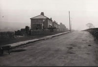
Although the houses along Newchurch Road form a continuous ribbon, this is relatively recent. Originally houses were sporadic (as illustrated on some of the maps on the map page under Albums) and were gradually infilled, finally becoming continuous in the 1980s.
When numbers were allocated there were many gaps in the ribbon and the numbers were allocated on the basis that the gaps would be filled with Victorian-sized terraces.
They weren’t. They were filled with peri-war semi-detached with relatively large gardens. As the gaps were infilled the numbers were counted up from Rawtenstall and down from Higher Cloughfold, with the gap at Marl Pits.
There is then a 20 yard gap with the entrance to Marl Pits sports ground.
The houses then resume with no 294 and descend in sequence from there down to Rawtenstall about 1/2 mile away.
Although the houses along Newchurch Road form a continuous ribbon, this is relatively recent. Originally houses were sporadic (as illustrated on some of the maps on the map page under Albums) and were gradually infilled, finally becoming continuous in the 1980s.
When numbers were allocated there were many gaps in the ribbon and the numbers were allocated on the basis that the gaps would be filled with Victorian-sized terraces.
They weren’t. They were filled with peri-war semi-detached with relatively large gardens. As the gaps were infilled the numbers were counted up from Rawtenstall and down from Higher Cloughfold, with the gap at Marl Pits.