
Local traditions - round the hills walk
07/09/14 23:31
The Rossendale Round the Hills walk is an 18 mile walk which goes, err, around the hills. It vaguely follows the old boundary of the former borough of Rawtenstall. Vaguely.
It is not a traditional ‘beating of the bounds’ type walk, being started in 1967 by Walter Whittaker as a family friendly community event, though the families have to be of a certain age to manage all 18 miles. It is now run jointly by Rossendale Rotary Club and Rossendale Harriers, and is still free to enter although donations welcome.
The first Sunday in September sees around 300 people start off from Marl Pits sports complex (100 yards along the road and on land historically belonging to Springhill Farm). The route then passes down Newchurch Road to Rawtenstall, up Haslingden Old Road and pate the ski slope Cribden. Traditionally it then went along the side of Cribden and the summit is not on a right of way and was inaccessible (cough) until opened up by the CROW Act. The use of footpaths on Cribden is closely monitored by a local farmer who has used voice (regularly) dogs (occasionally) and in more lurid versions shotguns (allegedly) to keep ramblers on the straight and narrow.
From Cribden the walk passes along the tops to Hambledon Hill past the ‘weather station’ to drop down by Clowbridge Reservoir (adjacent to the site of Gambleside Colliery, once owned by John Ashworth of Springhill House). It then passes past Compston’s Cross (commemorating Samuel Compston, father of EL Compston of Springhill House... theme emerging here) to Water. The route then passes up Dean Lane to Jack Lodge, alone Edgeside Lane to Waterfoot, losing some every year in the Jolly Sailor. It then passes up Lench and over Cowpe Lowe to Cloughfold, going through the quarry scrubbing mill at Cloughfold, visible from Springhill House...
You are now about half a mile from the end but it is up Peel Street, only 1:10 gradient but a killer after 18 miles. The route then passes along Newchurch Road past Springhill (where to temptation to just go home and not finish has to be resisted) and back to Marl Pits. Then, to add the final insult, you have to go upstairs to get your certificate.
It was a glorious day this year and I had to work...
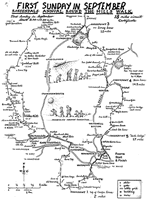
A description of the walk is given here.
(Occasionally, as on this map, the walk starts at Fearns school in Waterfoot but the circuit is the same. The last 2.5 miles have more downhill if you start there)