
G is for geology
08/04/14 09:03
I suppose in a way all history can be traced back to geology, or a lot of it at any rate. The nature of the ground and the resources it contains determine the uses to which it is put. This in turn determines who lives here and when, with changing uses at different times resulting in people moving in and out and doing different things whilst they are here.
Springhlll must have been a pretty inhospitable place in early times - remote, wet and windy. Acidic clay soil which does not drain doesn’t lend itself to arable farming and supports a mixture of mosses (especially sphagnum, beloved of bogs everywhere) and poor quality moorland grasses with standing water in the fields over much of winter. No wonder C16 surrenders include such fields as ‘Bad Pasture’. So it is no surprise that even at Domesday it is included in land ‘between the Ribble and the Mersey’ with the nearest town mentioned by name being Blackburn some 12 miles away. In those days it was used initially as a hunting forest for the lord of the manor (known as a forest, Rossendale was more strictly a chase) but by C13 the hunting was confined to a small deer park in Musbury about 3 miles away and the rest of the forest used for oxen farming. Presumably it made more money that way.
Gradually it was discovered that the land lay over outcrops of the lower Pennine coal measures. These thin seams (in places only 18” high but still worked) were close to the surface and so suitable for open cast mining in many cases. Small scale mining was established in the moors above Springhill by the C16, later the main collieries in Rossendale were part owned by a Springhill resident (yes, Ashworth again).
Later still, after the industrial revolution, the availability of glacial valley floors with a steady supply of flowing water located not too far (approx 20 miles) from Manchester meant that the area was ideal for factory development. And develop they did - wool, cotton, felt, slippers even mineral water. This changed the landscape and history of the area with the influx of people to staff the mills, initially from elsewhere in the UK than latterly from the Indian subcontinent. People need houses ... and schools ... and places of worship ... and ... but the rapid development of Rossendale in C19 only occurred because the geology was suitable. This increased the demand for coal so mining developed too.
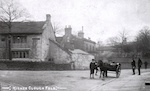
The stone locally is of high quality ‘Haslingden Flag’, used in the paving of Trafalgar Square and much of St Anne’s on Sea (indeed the entire town was largely founded by Rossendale people). Railways made quarrying a viable option and the hills are littered with the remains of the quarries. Stone was cheap so many houses were stone rather than brick and flag walling is common - there is a flag wall on Springhill lane. Again, only possible because the geology was the way it was.
We often relate events which occurred in our place to the wider social and historical context but it is helpful to relate it to the underlying landscape and geology too. It helps answer the question ‘why did this occur here?’
Springhlll must have been a pretty inhospitable place in early times - remote, wet and windy. Acidic clay soil which does not drain doesn’t lend itself to arable farming and supports a mixture of mosses (especially sphagnum, beloved of bogs everywhere) and poor quality moorland grasses with standing water in the fields over much of winter. No wonder C16 surrenders include such fields as ‘Bad Pasture’. So it is no surprise that even at Domesday it is included in land ‘between the Ribble and the Mersey’ with the nearest town mentioned by name being Blackburn some 12 miles away. In those days it was used initially as a hunting forest for the lord of the manor (known as a forest, Rossendale was more strictly a chase) but by C13 the hunting was confined to a small deer park in Musbury about 3 miles away and the rest of the forest used for oxen farming. Presumably it made more money that way.
Gradually it was discovered that the land lay over outcrops of the lower Pennine coal measures. These thin seams (in places only 18” high but still worked) were close to the surface and so suitable for open cast mining in many cases. Small scale mining was established in the moors above Springhill by the C16, later the main collieries in Rossendale were part owned by a Springhill resident (yes, Ashworth again).
Later still, after the industrial revolution, the availability of glacial valley floors with a steady supply of flowing water located not too far (approx 20 miles) from Manchester meant that the area was ideal for factory development. And develop they did - wool, cotton, felt, slippers even mineral water. This changed the landscape and history of the area with the influx of people to staff the mills, initially from elsewhere in the UK than latterly from the Indian subcontinent. People need houses ... and schools ... and places of worship ... and ... but the rapid development of Rossendale in C19 only occurred because the geology was suitable. This increased the demand for coal so mining developed too.
The stone locally is of high quality ‘Haslingden Flag’, used in the paving of Trafalgar Square and much of St Anne’s on Sea (indeed the entire town was largely founded by Rossendale people). Railways made quarrying a viable option and the hills are littered with the remains of the quarries. Stone was cheap so many houses were stone rather than brick and flag walling is common - there is a flag wall on Springhill lane. Again, only possible because the geology was the way it was.
We often relate events which occurred in our place to the wider social and historical context but it is helpful to relate it to the underlying landscape and geology too. It helps answer the question ‘why did this occur here?’