
This was originally prepared as an in-depth report on this study for the Society of One-Place Studies.
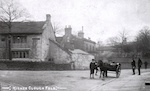
Springhill is a cluster of 12 houses in the village of Higher Cloughfold, in the historical borough of Rawtenstall (Rossendale post 1974), Lancashire. It is predominantly the buildings associated with the estate of Springhill House which was built in c 1840, however the earliest building in the cluster dates from 1641.
Geography
The use to which a place is put depends in so many ways on its geography and geology and Springhill is no exception.
The bedrock geology of the wider area is largely millstone grit with outcrops of Pennine lower coal measures formation. These were mined extensively by Springhill resident John Ashworth and partners to supply the emerging textile and footwear trades in the late 18th and 19th centuries.
The soil is acidic, clayey and very boggy. Arable production is minimal. Although legally a hunting ground or chase (and is still known as the Forest of Rossendale), the area was used for vaccaries or oxen farming until being released from forest law in 1507 then small scale pastoral farming. The soil required regular liming or marling, and the local Marl Pits was owned by a Springhill resident.
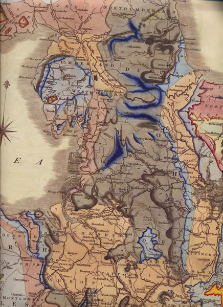
In landscape terms the area is part of a settled valley with enclosed uplands and moorland fringes to the north.
Springhill is a cluster of 12 houses in the village of Higher Cloughfold, in the historical borough of Rawtenstall (Rossendale post 1974), Lancashire. It is predominantly the buildings associated with the estate of Springhill House which was built in c 1840, however the earliest building in the cluster dates from 1641.
Geography
The use to which a place is put depends in so many ways on its geography and geology and Springhill is no exception.
The bedrock geology of the wider area is largely millstone grit with outcrops of Pennine lower coal measures formation. These were mined extensively by Springhill resident John Ashworth and partners to supply the emerging textile and footwear trades in the late 18th and 19th centuries.
The soil is acidic, clayey and very boggy. Arable production is minimal. Although legally a hunting ground or chase (and is still known as the Forest of Rossendale), the area was used for vaccaries or oxen farming until being released from forest law in 1507 then small scale pastoral farming. The soil required regular liming or marling, and the local Marl Pits was owned by a Springhill resident.
In landscape terms the area is part of a settled valley with enclosed uplands and moorland fringes to the north.
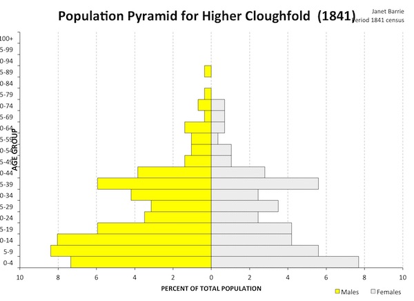
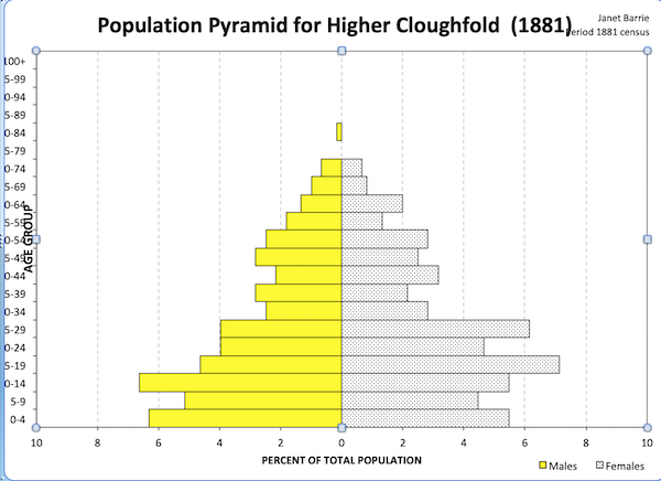
Population
A precise count of the population of Springhill is difficult as the enumerators rarely specified particular houses on the census with most being enumerated under the name of the wider district. As far as can be ascertained the number of houses in Springhill remained constant (at 10) over the nineteenth century. The population was also relatively constant, with the biggest variables being the number of children and the number of servants. The latter increased significantly in the 1850s when the owner of Springhill House married and her new husband suddenly had the need to hire a coachman, groom, gardener…
In 1881 Springhill comprised:
19 males of whom 7 were aged 13 or under and enumerated as scholars.
21 females of whom 4 were aged 13 or under.
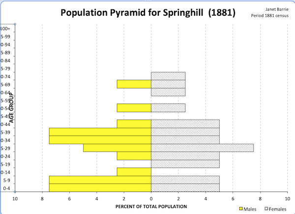
The village of Higher Cloughfold, of which Springhill is part, also remained relatively static over the century, although the population of the township grew markedly as industrialisation developed. The population became more youthful between 1841 and 1881, with a slight increase in females over the years. There is also a slight increase in the numbers living beyond 60 as the century progressed.
History
The land of Springhill formed part of the Blackburn Hundred which was granted by William the Conqueror to Roger de Poitou. In time it became part of the Honour of Clitheroe which passed through the de Lacy family to become part of the Duchy of Lancaster. At this time Rossendale (of which Springhill is part) was subject to forest law, although it was mainly used for cattle rearing. The number of tenant farmers gradually increased and the area was removed from forest law in 1507. It then became part of the manor of Accrington New Hold, still within the Honour of Clitheroe, and subject to the customs of the manor. Farming was supplemented by the domestic woollen industry. The first property in Springhill comes from this period, dated 1642.
With industrialisation came the development of woollen then cotton mills supported by an expanding coal industry. Springhill house was built c 1840 by John Ashworth, woollen manufacturer and colliery owner. This is located just north of the Haslingden-Todmorden turnpike road, in which Ashworth was an investor. Various outbuildings were constructed around this time.
By the end of the 19th century the houses in Springhill were held in Trust for Ashworth’s great niece. Some properties were subdivided, others incorporated into other dwellings, yet more formed from the conversion of outbuildings.
Economy
The land is poor quality for farming and the early economy was based on cattle rearing supplemented by the domestic woollen industry operating under a chapman system. The damp climate and river systems made the wider area suitable for industrialisation; initially this was mainly woollen but later the cotton, footwear and felt industries predominated. The development of the steam engine made the relatively thin coal seams viable to work and lead to an extensive network of mines. The coming of the railway made quarrying economical.
With the decline of the mills in the latter half of the 20th century, the wider area became predominantly a commuter town for Manchester, 25 miles to the south.
Worship
Springhill was in the ancient parish of Whalley, the second largest in England but twelve miles away over rough moorland. As the population grew after deforestation a Chapel of Ease was erected at Newchurch, approx. 3/4 of a mile away. This became parochial in 1550 following a petition from the residents.
There has always been a culture of dissent in the area. Sion Baptist church in Springhill can trace its history back to a ‘Dissenting Congregation’ (presumably Independents) being granted a licence to meet in the barn of John Piccop in 1672. Whilst the congregation was presumably active before this, the myth that the curate of Newchurch resigned his living following the Act of Conformity in 1662 appears to be without foundation. A Quaker meeting was established approx 1/4 mile from Springhill, initially in a private residence with an adjacent burial ground dated 1663. The extend of Catholic recusancy in the area is unknown but the Towneley family of Towneley Hall, Burnley (approx eight miles north) were a well known local recusant family. John Wesley preached about a mile away in 1748 to a ‘congregation of wild men’ whom it ‘pleased God to hold in chains’ and a Methodist chapel was build, again about a mile away, in 1761. There is also a Spiritualist gathering dating from 1888 and a Unitarian congregation within a similar distance. Despite its size, Springhill is linked with many of these congregations, with one property having been the Baptist manse and a Unitarian minister living at another.
The 1851 religious census does not go into the degree of detail to identify where Springhill residents worshipped. The parish church reported attendance of 680 in the morning and 1200 in the afternoon, the Baptists 353 (morning) and 427 (afternoon), Unitarians 260 (morning) and 252 (afternoon), Wesleyan Methodists 342 (morning) 456 (afternoon) and 219 (evening) whilst the Israelite Meeting Room reported 18 (morning) and 15 (afternoon). The rector of Newchurch regarded the survey as ‘inquisitive and impertinent’ being ‘without the standing of legally constituted authority’.
Although religious observance declined over the 20th century the parish church, Methodists, Baptists and Spiritualists are still active locally, as are the Quakers although they now worship some distance from Springhill.
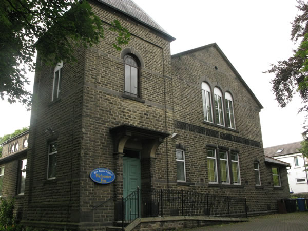
Sion Baptist Chapel, converted from the original Sunday School.
Community Life
The social life of the village in the 19th and first half of the 20th century would have centred round two main aspects:
- • the church, of which the main influences would be Sion Baptist Church in Springhill itself, the parochial church of St Nicholas Newchurch and latterly (from 1860) St John Cloughfold and the Methodist churches of which the nearest were Cloughfold and Hareholme.
- • the pub, of which the Red Lion and the Weavers’ Arms were in the village itself, together with one independent beer seller in 1871. There is no record of a temperance bar in the immediate locality, but one was established a mile away in 1890.
In addition the Cawl Terrace Industrial Society, established about half a mile away in 1860, had a reading room available to subscribers.
The road to the south of Springhill through the main village was Turnpiked in the early 19th century and would have improved the ease of communication. According to the 1818 Trades directory for Bacup there was a coach to Manchester every Tuesday morning at 5o’clock and carrier to Manchester every Friday morning at 10 o’clock. By 1879 (Slater’s) there were carriers to blackburn twice weekly. The railway was completed in 1852 and the area was never served by canals.
By 1818 there was a fair in Newchurch on 29th April and 30th September. This continued throughout most of the 19th century and Springhill resident Charles Patrick won various prizes for agricultural exhibits.
Travel and Migration
There are two documented examples of in-migration in the 18th century, both from within Lancashire. Census data in the 19th century demonstrates that there were increasing numbers of in-migrants between 1841 and 1881 after which residents predominantly had local places of birth. Most migrants came from adjacent places in Lancashire and South or East Yorkshire. However there were a cluster of families from East Anglia in this period. The only example of international in-migration was from Rhode Island in the 1870s.
Out-migration is more difficult to determine as places of birth on remote censuses tend not to be documented in a sufficiently detailed manner. In the wider area there was a steady stream of late 19th century migrants to the US, particularly Utah under the influence of the Church of Latter Day Saints. I am not aware of any Springhill residents who migrated in this way.
Of the gravestones in Sion Baptist Chapel, 95 names have places attached, of which 15 are for places more than five miles from the chapel. Some of these are of former residents who have moved away, for others the connection with Sion is not known, although there were a flurry of retirements to St Annes on Sea in the first two decades of the 20th century.
Families and Notable People
Springhill House was built by John Ashworth in c 1840. He left it to his daughter Mary Ann, Mrs Charles Patrick. Patrick lived there until his death in 18XX. It then passed in Trust to her niece, Elizabeth Ann Turner who managed it until her death in 1923.
In 1923 the estate was bought by John Hart who lived in Polefield Cottage. His sister lived in one cottage together with her husband, whilst his brother in law and his wife lived in another.
Sunset View was bought in 1934 by Harry Taylor, it was then left to his daughter who sold it to her daughter. Together with Taylor’s mother in law and great grandson, six generations of the same family have lived there.
Springhill House was bought be Hubert and Ada Taylor in 1948. At least two further generations of the family lived there.
Springhill Farm was managed by the Spence family for over 100 years until 2004.
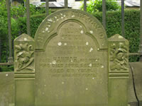
Grave of William and Hannah Spence, approximately 20 yards from their farmhouse.
Further Reading
- • The Economic History of Rossendale by G H Tupling
- • The Royal Forests of England by J C Cox
- • The History of the Forest of Rossendale by T Newbigging
- • Rambles Around Rossendale by J M Mather
- • Bobby Dazzler by E M Hood
Resources
Numerous resources have been used as part of this study. Some of the major ones include:
- • Parish records of St Nicholas, Newchurch and the records of Sion Baptist Church and the Crawshawbooth Quaker Meeting
- • Census data 1841-1911, the 1851 religious census.
- • The 1910 Land Survey
- • The 1939 Register
- • Manorial records and title deeds
- • Newspapers
- • Fieldwork, photographs and maps
- • Colliery records
- • Trades directories
- • Polite nosiness.