
some things never change
17/02/15 22:11
Whilst Springhill itself has never flooded to the best of my knowledge, there are a number of factors which make the wider area liable to flooding:
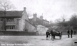
There was an extensive flood in Rossendale in 1911 resulting in ‘tons of debris’ being deposited on Edge Lane adjacent to Sion chapel (amongst numerous other places).
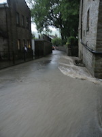
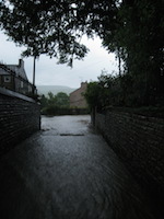
History repeated itself on 22 June 2012 when flash floods made their way down Edge Lane and onto Newchurch Road…
 Edge Lane looking S and N
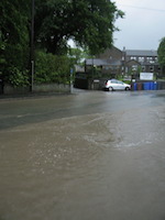 Edge Lane looking S, Newchurch Road
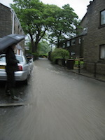
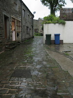
Yet the flood didn’t touch Springhill itself as this picture from the same spot as the first one above, looking W instead of S illustrates…
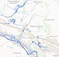
The Environment Agency identifies Edge Lane, Johnny Barn Close, Johnny Barn Farm and Newchurch Road as High Risk areas and Johnny Barn Cottages as Medium Risk. Springhill is at no appreciable risk. Interesting as it is just round the corner.
- underlying poorly draining clay soil combined with a heavy rainfall,
- culverted Parrock brook which isn’t dredged
- two downhill roads meeting in a slightly hollowed part of the village
- some houses on Newchurch Road being set at slightly below road level
- mid C19 plumbing system taking water from the underground reservoirs on Seat Naze to the Springhill properties
- potentially exacerbated by proposed building on the field behind Johnny Barn Close.
There was an extensive flood in Rossendale in 1911 resulting in ‘tons of debris’ being deposited on Edge Lane adjacent to Sion chapel (amongst numerous other places).
History repeated itself on 22 June 2012 when flash floods made their way down Edge Lane and onto Newchurch Road…
Edge Lane looking S and N Edge Lane looking S, Newchurch RoadYet the flood didn’t touch Springhill itself as this picture from the same spot as the first one above, looking W instead of S illustrates…
The Environment Agency identifies Edge Lane, Johnny Barn Close, Johnny Barn Farm and Newchurch Road as High Risk areas and Johnny Barn Cottages as Medium Risk. Springhill is at no appreciable risk. Interesting as it is just round the corner.