
April 2020
52 residents #17 land
25/04/20 22:15
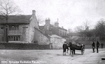
Land can have value for a number of purposes. In the early days the land on which Springhill now stands was subject to Forest law. Strictly speaking it was a chase (hunting land for the Lord of the Manor) rather than a Forest (hunting land for the King) although there is no evidence that recreational hunting ever took place here. By the 14th century the deer for hunting were gathered in a park in Musbury, near Helmshore, and the rest of the 'Forest of Rossendale' was let to a small number to tenants for vaccary farming. The land is poor quality farming land, being acidic peat/clay soil with stony ground and steep, hillside slopes. Vaccary farming must have been a precarious existence then. Nevertheless buy the late 15th/early 16th century the land was being encroached by smallholder farmers who supplemented their income by the domestic woollen trade. This way of life continued from the time the land emerged from Forest Law in 1507 to the industrial revolution. Incidentally the 'forest' bit of the 'Forest of Rossendale' (the historical name for the area) relates to this jurisdiction and has nothing to do with the number of trees. The legend that 'a squirrel could jump from [one end of Rossendale to the other, about 6 miles] without touching the ground' was probably always that, a legend.
At the industrial revolution it became apparent that the land was ideally suited for the emerging industries. There was running water to drive the water wheels and, later, steam mills. There was a damp atmosphere so the cotton was less likely to break. There was good quality local stone to quarry to build factories, and houses for the workers to live in.
And there was coal. Not very good quality coal, granted, and in seams which were not very deep but it was there and the development of the steam engine needed a ready supply of coal to fuel it. The coal in the hillsides, which had been mined in a small-scale manner since medieval times, became worth exploiting. Enter two families, the Hargreaves and the Ashworths. Together these families formed Ashworth Hargreaves ltd (later Rossendale Colleries) who ran about half of the local collieries. They were big players in the local coal industry. One of their members, John Ashworth, bought the land on which Springhill now stands and built Springhill House in about 1825. It isn't the first house in the area with an adjacent property dating back to the mid C17, but it is the most prominent. The coal mines gradually became less profitable in the mid 20th century and mining fizzled out as an occupation in the area, despite occasional attempts to restart drift mining about 4 miles away. The cotton and footwear mills had long since gone over to electricity as a course of power and it was poor quality for the domestic market.
With the demise of the mills the land took on a different purpose and its value lay in its utility for housing, leisure or retail/light industry. These are keenly fought over, with recent planning applications in the area being contested by residents on a variety of grounds.
52 residents #15 fire
11/04/20 22:14
In 1916 a Zeppelin followed the River Irwell through Rawtenstall and Bury, instead of its intended path along the Rochdale Canal to Manchester. It dropped two bombs in Rawtenstall:
It is said that the incendiary was carried down to the tram station at Cloughfold, about half a mile, by a special constable who then took it on the tram to the police station in Rawtenstall for investigation. It is now in the Whitaker museum, Rawtenstall.
Wouldn't have wanted his job.
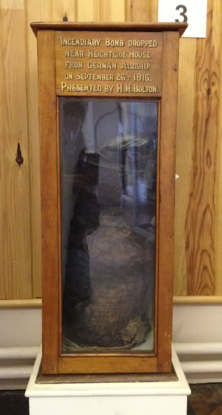
- an incendiary device which landed in the grounds of Heightside House
- an explosive device which landed in the grounds of Lea Bank
It is said that the incendiary was carried down to the tram station at Cloughfold, about half a mile, by a special constable who then took it on the tram to the police station in Rawtenstall for investigation. It is now in the Whitaker museum, Rawtenstall.
Wouldn't have wanted his job.
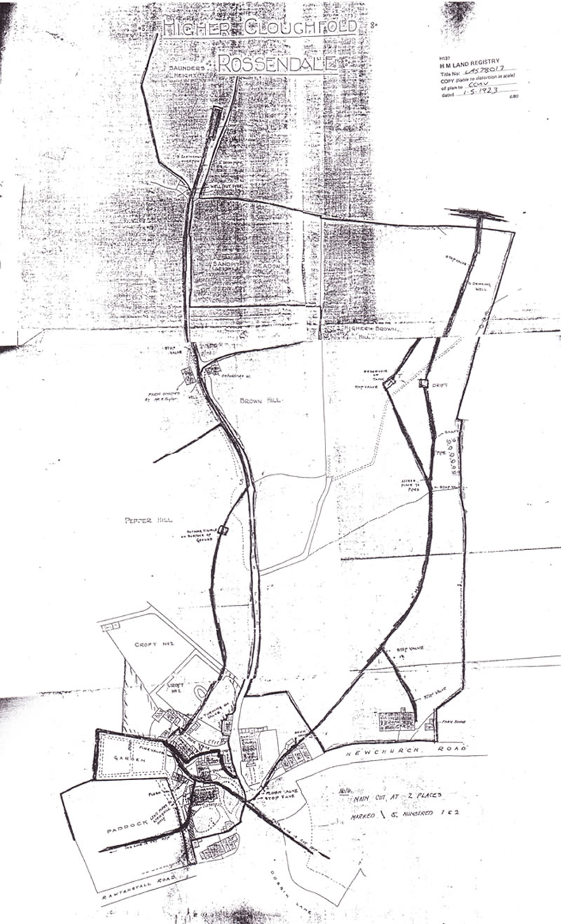
52 residents #14 water
03/04/20 22:14
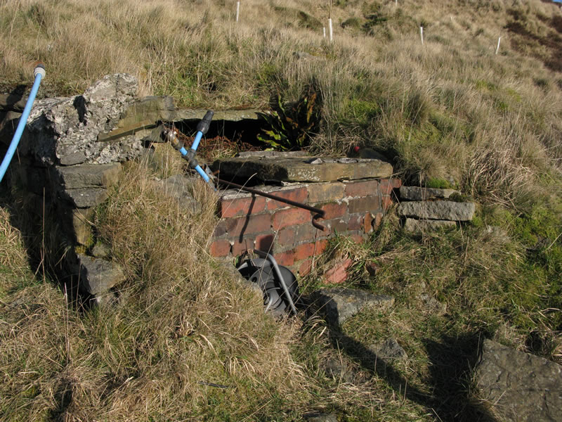
Springhill Resident Charles Patrick died in 1895 and left a codicil to his will referring to the 'water in Saunder Height'.
Patrick was a major landowner in his own right and also via his marriage to Mary Ann Ashworth, who as the heiress of John Ashworth, coal merchant, had a considerable portfolio of his own. Patrick had no children of his own and left his local property to the nieces of his wife, who had predeceased him. These were put into trust on the marriages of the nieces.
At the time of drawing up his will he had bought a field at Saunder Height, about 300 yards up the hill behind Springhill which was left to Elizabeth Ann Turner, nee Ashworth. An adjacent close was left to her sister Mary Alice Royds, nee Ashworth. Since writing the will he had taken borings and discovered a source of water in the land left to Mrs Turner which was capable of supplying the properties in the Springhill area. He then wished both sisters to benefit equally from this discovery so added a codicil revoking the allocation of the closes and directing that each should share the profits but also be able to 'lay down such pipes and culverts at they think fit' to use the water to supply their properties without the consent of the other.
I would love to know how that worked in practice, with the potential for chaos that opens up. However some of the Springhill properties are still supplied from the Saunder Height supply.