
July 2014
what constitutes a link to a place?
25/07/14 22:28
I was transcribing the gravestones in Sion churchyard recently and was struck by the number of people buried there in the C19 who did not live in the immediate area. Most lived within a mile or so of Sion, but some obviously travelled considerable distance to worship and passed other Baptist churches on the way. Yet they were obviously connected sufficiently with Sion to be buried there.
So do they qualify for inclusion in a one-place study? What connection with a place is necessary to ‘count’? It’s not as easy as it seems!
Obviously study people who lived there - but for how long should someone have lived there? What about boarders on the census returns - should their link with the householder be followed up?
What about major landowners who never lived there? Springhill was copyhold land subject to the customs of the manor. Obviously study the copyhold holder but what about the lord or the steward?
There may be major employers with workers who spent all their working lives in the place but lived elsewhere. Alternatively a resident may have had a significant role - employed, voluntary, whatever - outside. How far do you study that up?
Marl Pits, once part of Springhill Farm, how hosts a sports complex with rugby and athletics club - should I study major club officials or key members, even if that was their only link to the area?
And when does it get silly - people who passed through on the bus...
Ultimately it is a personal study so it doesn’t really matter as long as the link is documented and explored consistently. Maybe the inclusion criterion is ‘whatever grabs my interest’!
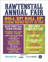
Local traditions - the Rawtenstall Annual Fair
12/07/14 23:01
Immortalised in song by the Houghton Weavers and here by Lee Nicholson, the apocryphal Rawtenstall Annual Fair included sideshows of 40 ‘stone’ ladies, tattooed ladies, mermaids and the house o’myst’ry with a number of mishaps perpetrated by ‘the lads’ and a touch of general smut. The song has been described as ‘good rugby song stuff for the coach back from the game’ (but clean!). Incidentally the ‘coal pits up at Burnley’ referred to in the song have long gone...
There is no good evidence of a historic annual fair of this nature, rather local fairs included prizes for the best examples of a range of agricultural produce. Captain Patrick of Springhill was a regular entrant and won a number of prizes for, e.g., carriage horses, sucking pigs and geese.
Four years ago a local community group restarted the ‘Rawtenstall Annual Fair’, initially as a food/craft market with some chlldren’s stalls. It has since developed as a forum for local musicians/dancers/DJs to have the opportunity to perform live in public in the open air. But no mermaids.
In addition this year the local museum (now run by a community group after being closed by the County Council last year) ran an afternoon of Lancashire song and dialect and storytelling. I remember Lancashire dialect from my childhood, now it has all but gone. It is interesting that the fair is developing to try and preserve traditions such as dialect poetry and storytelling which were never part of the historic fairs of the area.

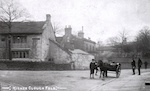
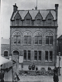
The pictures below are thought to date from ~1910
There is no good evidence of a historic annual fair of this nature, rather local fairs included prizes for the best examples of a range of agricultural produce. Captain Patrick of Springhill was a regular entrant and won a number of prizes for, e.g., carriage horses, sucking pigs and geese.
Four years ago a local community group restarted the ‘Rawtenstall Annual Fair’, initially as a food/craft market with some chlldren’s stalls. It has since developed as a forum for local musicians/dancers/DJs to have the opportunity to perform live in public in the open air. But no mermaids.
In addition this year the local museum (now run by a community group after being closed by the County Council last year) ran an afternoon of Lancashire song and dialect and storytelling. I remember Lancashire dialect from my childhood, now it has all but gone. It is interesting that the fair is developing to try and preserve traditions such as dialect poetry and storytelling which were never part of the historic fairs of the area.
The pictures below are thought to date from ~1910
Why is no 368 next to no 294?
05/07/14 22:36
Going through a neighbour’s deeds I found a list of tenants paying ground rent to the owners of Springhill Farm, together with date of tenancy and rent paid. Double checking which house was where showed that the numbers on the north side of Newchurch Road descend in order (apart from 388A but hey) from 420 to 368, all where you would expect them to be.
There is then a 20 yard gap with the entrance to Marl Pits sports ground.
The houses then resume with no 294 and descend in sequence from there down to Rawtenstall about 1/2 mile away.
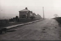
Although the houses along Newchurch Road form a continuous ribbon, this is relatively recent. Originally houses were sporadic (as illustrated on some of the maps on the map page under Albums) and were gradually infilled, finally becoming continuous in the 1980s.
When numbers were allocated there were many gaps in the ribbon and the numbers were allocated on the basis that the gaps would be filled with Victorian-sized terraces.
They weren’t. They were filled with peri-war semi-detached with relatively large gardens. As the gaps were infilled the numbers were counted up from Rawtenstall and down from Higher Cloughfold, with the gap at Marl Pits.
There is then a 20 yard gap with the entrance to Marl Pits sports ground.
The houses then resume with no 294 and descend in sequence from there down to Rawtenstall about 1/2 mile away.
Although the houses along Newchurch Road form a continuous ribbon, this is relatively recent. Originally houses were sporadic (as illustrated on some of the maps on the map page under Albums) and were gradually infilled, finally becoming continuous in the 1980s.
When numbers were allocated there were many gaps in the ribbon and the numbers were allocated on the basis that the gaps would be filled with Victorian-sized terraces.
They weren’t. They were filled with peri-war semi-detached with relatively large gardens. As the gaps were infilled the numbers were counted up from Rawtenstall and down from Higher Cloughfold, with the gap at Marl Pits.