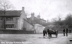

September 2014
same sex marriage
28/09/14 21:48
Same sex marriage became legal in England and Wales in 2014 so it was a bit of a surprise when a well known genealogy database reported that Thomas Ormerod married one of these people in q3 1899:
Elijah Taylor
Annie Harker
Annie Corrie
Sadly, as I knew he married an Annie, that didn’t much help.
But Elijah Taylor? Really?
Elijah Taylor
Annie Harker
Annie Corrie
Sadly, as I knew he married an Annie, that didn’t much help.
But Elijah Taylor? Really?
grave matters
27/09/14 21:54
The Springhill area has a long association with nonconformity, being home to at least one Baptist and two Unitarian ministers, the possibility that Polefield Cottage and Lodge Fold Cottage were early dissenters meeting places and the Friends’ burial ground on Chapel Hill. Sion Baptist Church, which dates back to 1672, is next to Springhill and it has long been one of my ambitions to transcribe its burial ground.
This summer I managed it. The results are on the Sion - gravestones page.
It started with a chance meeting with the assistant Pastor in Costa one morning. Permission granted, off I trot with coffee, notebook and camera and get going.
That’s when the problems start and decisions have to be made.
Firstly, worship in the church building ceased in the 1970s with the congregation meeting since then in the Sunday School building, a veritable palace of a place. The church fell into decay and in 1986 was demolished with the stone being used for sheltered housing flats. As part of this process the graveyard was tidied up with headstones being moved to the perimeter of the graveyard and other stones being grassed over. It is thought that a few of the stones were damaged in the process and the arrangement around the edges is completely arbitrary. No assumptions can be made about people named on adjacent stones as their original position was unknown.
I decided not to go in for gardening. I did push back ivy to read the underlying stone but did not feel comfortable exposing those parts of stones which were underground of covered by moss or grass. I was always conscious of being a guest at someone else’s burial place and in someone else’s garden. Being in someone else’s garden led to a few interesting conversations with the residents of the flats and picked up a number of OPS snippets that way.
Secondly, the renovations meant that the arrangement of the stones appeared random with only the major monuments remaining in situ. The first job was to draw up a plan, but the numbering was somewhat arbitrary, being vaguely clockwise from the left of the gate.
Thirdly, work and family meant that the main opportunities to visit were late Sunday afternoons. I know the theory about both transcription and photography: visit at different times of day under different lighting conditions, take a mirror or lightbox and the like. The reality is not that simple and the north facing stones are in shadow whatever time of day as the light is blocked by adjacent buildings.
However, it is done. And I learned a lot of interesting OPS stuff in the process:
Being intrinsically ‘share friendly’, I have made the data available to the local FH society and hope it is useful to others as well. Still lots of work to do to tease out all the ramifications which will keep me quiet over the long winter months.
This summer I managed it. The results are on the Sion - gravestones page.
It started with a chance meeting with the assistant Pastor in Costa one morning. Permission granted, off I trot with coffee, notebook and camera and get going.
That’s when the problems start and decisions have to be made.
Firstly, worship in the church building ceased in the 1970s with the congregation meeting since then in the Sunday School building, a veritable palace of a place. The church fell into decay and in 1986 was demolished with the stone being used for sheltered housing flats. As part of this process the graveyard was tidied up with headstones being moved to the perimeter of the graveyard and other stones being grassed over. It is thought that a few of the stones were damaged in the process and the arrangement around the edges is completely arbitrary. No assumptions can be made about people named on adjacent stones as their original position was unknown.
I decided not to go in for gardening. I did push back ivy to read the underlying stone but did not feel comfortable exposing those parts of stones which were underground of covered by moss or grass. I was always conscious of being a guest at someone else’s burial place and in someone else’s garden. Being in someone else’s garden led to a few interesting conversations with the residents of the flats and picked up a number of OPS snippets that way.
Secondly, the renovations meant that the arrangement of the stones appeared random with only the major monuments remaining in situ. The first job was to draw up a plan, but the numbering was somewhat arbitrary, being vaguely clockwise from the left of the gate.
Thirdly, work and family meant that the main opportunities to visit were late Sunday afternoons. I know the theory about both transcription and photography: visit at different times of day under different lighting conditions, take a mirror or lightbox and the like. The reality is not that simple and the north facing stones are in shadow whatever time of day as the light is blocked by adjacent buildings.
However, it is done. And I learned a lot of interesting OPS stuff in the process:
- how far some of the places named are from Springhill. Jersey? Germany?
- how many people retired to St Annes on Sea. I was aware of the strong connection between Rossendale and St Annes but it seemed like an awful lot of them
- that there are some very sad stories there which warrant further study. I would love to know the details of the obstetric disaster which befell poor Tattersall family.
- money didn’t protect, with some very rich people losing children
- William Spence of Springhill Farm being buried almost in his front garden - about 12 feet away.
Being intrinsically ‘share friendly’, I have made the data available to the local FH society and hope it is useful to others as well. Still lots of work to do to tease out all the ramifications which will keep me quiet over the long winter months.
Artefacts
14/09/14 20:17
Much of the material for one place studies comes from primary and secondary sources. Increasingly these are scanned and available online but there is still something special about seeing the original documents. Equally there is something about walking around the area of study, imagining what it was like in different ages when buildings were absent and others still standing. Artefacts are another means of connecting with a place and the people who lived there before. Usually artefacts are seen in museums but it was a privilege this weekend to see some in the context in which they were originally used.
This weekend was the heritage open day weekend when a large number of historical buildings are open to the public and display some aspects of their heritage. Yesterday I visited the Crawshawbooth Quaker Meeting House, opened in 1716. Prior to this the Quakers met in a private house on Chapel Hill and their burial ground is still there.
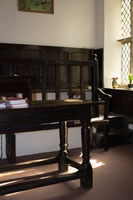
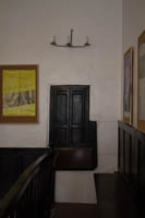
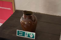
The Crawshawbooth Meeting House is virtually unchanged since is opened but of particular interest to me were three artefacts brought there from the old place of meeting. They were therefore older than the meeting house itself and were used during or after Quaker worship in the Springhill area in the late C17 and early C18. They are described in the history of the Meeting House.
The table
Tables, altars and pulpits do not feature in Quaker worship and this table was probably used for refreshments after the meeting. The cross bars are grooved from centuries of feet resting on them.
The candle holder
Obviously there were no electric lights when the Meeting House was opened and this candle holder was brought from the original meeting place. I don’t think the candles are original...
The pitcher
Friends travelled a considerable distance on foot or horseback to the Meeting House and this pitcher, said to be C16, contained wither water or wheat beer for their refreshment. It seems that they all shared a common cup. Its use now is solely ornamental, and to prop up the C21 ‘fire exit’ notice.
This weekend was the heritage open day weekend when a large number of historical buildings are open to the public and display some aspects of their heritage. Yesterday I visited the Crawshawbooth Quaker Meeting House, opened in 1716. Prior to this the Quakers met in a private house on Chapel Hill and their burial ground is still there.
The Crawshawbooth Meeting House is virtually unchanged since is opened but of particular interest to me were three artefacts brought there from the old place of meeting. They were therefore older than the meeting house itself and were used during or after Quaker worship in the Springhill area in the late C17 and early C18. They are described in the history of the Meeting House.
The table
Tables, altars and pulpits do not feature in Quaker worship and this table was probably used for refreshments after the meeting. The cross bars are grooved from centuries of feet resting on them.
The candle holder
Obviously there were no electric lights when the Meeting House was opened and this candle holder was brought from the original meeting place. I don’t think the candles are original...
The pitcher
Friends travelled a considerable distance on foot or horseback to the Meeting House and this pitcher, said to be C16, contained wither water or wheat beer for their refreshment. It seems that they all shared a common cup. Its use now is solely ornamental, and to prop up the C21 ‘fire exit’ notice.
Local traditions - round the hills walk
07/09/14 23:31
The Rossendale Round the Hills walk is an 18 mile walk which goes, err, around the hills. It vaguely follows the old boundary of the former borough of Rawtenstall. Vaguely.
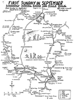
It is not a traditional ‘beating of the bounds’ type walk, being started in 1967 by Walter Whittaker as a family friendly community event, though the families have to be of a certain age to manage all 18 miles. It is now run jointly by Rossendale Rotary Club and Rossendale Harriers, and is still free to enter although donations welcome.
The first Sunday in September sees around 300 people start off from Marl Pits sports complex (100 yards along the road and on land historically belonging to Springhill Farm). The route then passes down Newchurch Road to Rawtenstall, up Haslingden Old Road and pate the ski slope Cribden. Traditionally it then went along the side of Cribden and the summit is not on a right of way and was inaccessible (cough) until opened up by the CROW Act. The use of footpaths on Cribden is closely monitored by a local farmer who has used voice (regularly) dogs (occasionally) and in more lurid versions shotguns (allegedly) to keep ramblers on the straight and narrow.
From Cribden the walk passes along the tops to Hambledon Hill past the ‘weather station’ to drop down by Clowbridge Reservoir (adjacent to the site of Gambleside Colliery, once owned by John Ashworth of Springhill House). It then passes past Compston’s Cross (commemorating Samuel Compston, father of EL Compston of Springhill House... theme emerging here) to Water. The route then passes up Dean Lane to Jack Lodge, alone Edgeside Lane to Waterfoot, losing some every year in the Jolly Sailor. It then passes up Lench and over Cowpe Lowe to Cloughfold, going through the quarry scrubbing mill at Cloughfold, visible from Springhill House...
You are now about half a mile from the end but it is up Peel Street, only 1:10 gradient but a killer after 18 miles. The route then passes along Newchurch Road past Springhill (where to temptation to just go home and not finish has to be resisted) and back to Marl Pits. Then, to add the final insult, you have to go upstairs to get your certificate.
It was a glorious day this year and I had to work...
A description of the walk is given here.
(Occasionally, as on this map, the walk starts at Fearns school in Waterfoot but the circuit is the same. The last 2.5 miles have more downhill if you start there)
remote infuences on your place
02/09/14 18:21
Lovely day so walk over Rooley Moor between Rossendale and Rochdale. It was thought originally to have been a medieval route linking Whalley Abbey and the monks of Spotland,
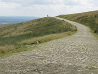
Much of Rooley Moor Road was setted in the mid 1860s, as a job creation scheme for Rossendale cotton workers impoverished by the cotton famine. This was a shortage of raw cotton to supply the mills due to the blockade of Confederate ports by Unionists during the American Civil war. The effect was profound, with short time working at best (with some cotton from India and Egypt), massive demands on poor-relief and near starvation.
in 1863 Parliament passed the Public Works (Manufacturing Districts) Act allowing local authorities to borrow at low interest to fund projects of public benefit. The setting of Rooley Moor Road was one of these, Alexandra Park in Oldham another.
Despite the hardship many Lancashire people supported Lincoln. In 1862 a group of mill girls sent a letter to Lincoln supporting his actions; his return acknowledged their hardship and praised their stance as ‘an instance of sublime Christian heroism”.
Other consequences were in the migration of individuals, many of whom left to seek work elsewhere. One of my ancestors has older and younger siblings born in Rossendale. She was born in Stockton on Tees, where her family went to seek work during the cotton famine.
The history of one place can be influenced by events far removed from it, and a one-place study may stretch out a very long way...