
S is for Springhill
26/03/14 17:17
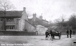
S is for Springhill, a collection of houses in the Higher Cloughfold area of Rossendale, Lancs. It is currently made up of 12 houses but this number has increased and decreased over the years as outbuildings have been converted to dwellings, a large house subdivided and smaller cottages knocked through. It is not special – nobody famous lived here and no national events occurred here. Yet this study illustrates many of the things which make a one-place study fascinating and frustrating. Sadly, they don’t all begin with ‘S’.
The first is a sense of identification with the place which often drives the study in the first place. Five generations of my family have lived in our house – each with different birth surnames so not obvious from the records. The history of my family is inexorably linked with the history of our house, and that of the larger house of which it was once part, and that of the estate attached to that mansion, and the village in which it is located, most of which was owned by the mansion owner.
This leads to the second illustration, that of boundaries. ‘Springhill’ as such only exists as a postal district. It isn’t marked on a map and many locals wouldn’t be able to give directions. Higher Cloughfold, the village, is on the map but has no clearly defined boundaries and merges into the next village. My ‘one place’ includes what I want it to include, which is fine as long as that is upfront.
Not being a defined place leads to problems with sources and source generation. In the past 150 years it has been part of 4 different local government administrations, 3 parishes and 3 parliamentary constituencies. All of these have widely different boundaries and contain areas with no historical or cultural affinity to each other. The 1911 census enumeration district boundary runs straight through the village, the 1841 equivalent doesn’t. These things make it very difficult to compare data over time or to compare civil and parish records.
The other problem with sources is survival or rather non-survival. There are no tithe map or enclosure records, the voters’ lists are missing for 40 years , the local paper was based 8 miles away until 1883. On the plus side the parish records go back to the 16th century and the tenancies were copyhold until 1926 with the court rolls available. It would be helpful if placenames were more specific – give us a clue where is ‘the big field’ or ‘the cow pasture’?
So why bother? The fun of the search and the delight when a gem is unearthed. The links across the centuries – Christopher Tattersall was fined for failing to maintain a highway in 1534 and the way in question is still impassable after rain. The questions raised – why does the area have two C17 nonconformist places of worship (both still in use)? The amusement of everyday life – Charles Patrick, a major landowner, had his name taken in vain in an attempt to procure some rabbits. The legend of the previous resident, onetime headmaster of the local school, whose ghost is said to walk the balcony. The insights into how people thought and lived. The fun of putting it all together. Learning from people with similar interests (www.one-place-studies.org). Most of all the sense of connectedness to a place which features strongly in my being who I am.